Samothrace
From Wikipedia, the free encyclopedia
| Samothrace Σαμοθράκη | |
|---|---|

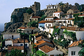
View of the Chora (Samothraki)
| |
| Coordinates: 40°29′N 25°31′ECoordinates: 40°29′N 25°31′E | |
| Country | Greece |
| Administrative region | East Macedonia and Thrace |
| Regional unit | Evros |
| Area | |
| • Municipality | 178.0 km2 (68.7 sq mi) |
| Highest elevation | 1,611 m (5,285 ft) |
| Lowest elevation | 0 m (0 ft) |
| Population (2011)[1] | |
| • Municipality | 2,859 |
| • Municipality density | 16/km2 (42/sq mi) |
| Community | |
| Time zone | EET (UTC+2) |
| • Summer (DST) | EEST (UTC+3) |
| Postal code | 680 02 |
| Area code(s) | 25510 |
| Vehicle registration | ΕΒ |
| Website | www.samothraki.gr |
Samothrace (also Samothraki) (Greek: Σαμοθράκη, [samoˈθraci]) is a Greek island in the northern Aegean Sea. It is amunicipality within the Evros regional unit of Thrace. The island is 17 km (11 mi) long and is 178 km2 (69 sq mi) in size and has a population of 2,859 (2011 census). Its main industries are fishing and tourism. Resources on the island include granite andbasalt. Samothrace is one of the most rugged Greek islands, with Mt. Saos and its tip Fengari rising to 1,611 m.
Landscape[edit]
Samothrace (also Samothraki) (Greek: Σαμοθράκη, [samoˈθraci]) has a beautiful landscape, with Mt Fengari as the centerpiece of the island.
Communities[edit]
- Alonia (pop. 291 in 2011)
- Ano Karyotes (22)
- Ano Meria (57)
- Dafnes (16)
- Kamariotissa (1,069)
- Kato Karyotes (41)
- Katsampas (15)
- Lakkoma (317)
- Makrylies (12)
- Palaiopoli (36)
- Potamia (6)
- Profitis Ilias (189)
- Samothrace/Samothraki (653)
- Therma (106)
- Xiropotamos (29)


Δεν υπάρχουν σχόλια:
Δημοσίευση σχολίου