Milos
From Wikipedia, the free encyclopedia
For the Slavic male name, see Miloš. For the refugee ship, see Patria disaster.
- Melos redirects here; for the Japanese short story, see Run, Melos.
| Milos Μήλος | |
|---|---|

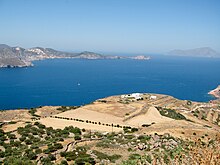
Milos Island in August 2014.
| |
| Coordinates: 36°41′N 24°25′ECoordinates: 36°41′N 24°25′E | |
| Country | Greece |
| Administrative region | South Aegean |
| Regional unit | Milos |
| Area | |
| • Municipality | 160.1 km2(61.8 sq mi) |
| Highest elevation | 748 m (2,454 ft) |
| Lowest elevation | 0 m (0 ft) |
| Population (2011)[1] | |
| • Municipality | 4,977 |
| • Municipality density | 31/km2 (81/sq mi) |
| Community | |
| • Population | 819 |
| Time zone | EET (UTC+2) |
| • Summer (DST) | EEST (UTC+3) |
| Postal code | 840 xx |
| Area code(s) | 22870 |
| Vehicle registration | EM |
| Website | www.milos.gr |
Milos or Melos (/ˈmɛlɒsˌ -oʊsˌ ˈmiːlɒs, -loʊs/; Modern Greek: Μήλος [ˈmilos]; Ancient Greek: Μῆλος Melos) is a volcanic Greekisland in the Aegean Sea, just north of the Sea of Crete. Milos is the southwesternmost island in the Cyclades group.
The island is famous for the statue of Aphrodite (the "Venus de Milo", now in the Louvre), and also for statues of the Greek godAsclepius (now in the British Museum[2]), the Poseidon and an archaic Apollo in Athens. Milos is a popular tourist destination during the summer. The Municipality of Milos also includes the uninhabited offshore islands of Antimilos and Akradies. The combined land area is 160.147 square kilometres (61.833 sq mi) and the 2011 census population was 4,977 inhabitants.
History[edit]
Obsidian from Milos was a commodity as early as 15,000 years ago.[3] Natural glass from Milos was transported over long distances and used for razor sharp "stone tools" well before farming began and later: "There is no early farming village in the Near East that doesn't get obsidian".[4] However the mining of obsidian did not lead to the development of permanent habitation or manufacturing on the island. Instead, those in search of obsidian arrived by boat, beaching it in a suitable cove and cutting pieces of the volcanic glass from the quarries.[5]
The position of Milos, between mainland Greece and Crete, and its possession of obsidian, made it an important centre of early Aegean civilisation. Milos lost its arms-making importance when bronze became the preferred material for the manufacture of weapons.[6]
The first settlement at Phylakopi (Greek Φυλακωπή) arose in the Bronze Age, flourishing as the extraction of obsidian was in the decline. The first settlers were tuna fishermen.[5] Lying on the north-east coast, excavations by the British School of Archeology revealed a town wall and a Minoan-inspired structure, dubbed the Pillar room, which contained fragments of vivid wall paintings. The famous fresco of the flying fish[7] was found in the ruins of the Pillar room and was executed with delicate colouring and graphic observation of nature in the graceful movement of a fish. Stylistic similarities to Minoan frescoes are suggested, and it could perhaps have been the work of a Cretan artist.[8] Part of the site has been washed away by the sea.
The antiquities found at the site covered three major periods, from the Early Cycladic period to the Mycenaean period Mycenaean age of Greece. At the site much pottery was excavated, with several changing styles and influences over the sites long occupation. In the early occupation of the site, there are many similarities and imports from other Cycladic islands and the settlement was very small. During the Middle Bronze Age however the site expanded significantly and the expansion of Minoan Crete saw an influx of Minoan pottery into the Cyclades, particularly at Akrotiri on Thera, though much found its way to Phylakopi. The quantities found at the Cycladic sites have been taken to suggest a Minoan control over the region, though it could also be the consumptive nature of the islanders adopting Cretan fashions. There is more than just pottery at Phylakopi however, the eruption of the Thera volcano saw a reduction in Minoan presence in the Cyclades and it is at this time that Mycenaean involvement on the islands increases. At Phylakopi (and unknown in the rest of the Cyclades) a Megaron structure, which is typically associated with the Mycenaean palaces, such as those at Tiryns, Pylos and Mycenae has been discovered. This has been taken to suggest that the Mycenaeans conquered the settlement and installed a seat of power for a governor. The evidence is not clear, though again it could be a legacy of the islanders adopting foreign elements into their culture. Particularly unexpected was the discovery in the 1970s of a shrine at the site, which contained many examples of Aegean figurines, including the famous "Lady of Phylakopi". The shrine is unprecedented in the Bronze Age Cyclades and has provided a valuable insight ito the beliefs and rituals of the inhabitants of Phylakopi. The site was eventually abandoned and was never reoccupied.
In historical times, the island was occupied by Dorians from Laconia. In the 6th century BC, it again produced a remarkable series of vases, of large size, with mythological subjects and orientalizing ornamentation, and also a series of terra-cotta reliefs (Melian Reliefs).
Climate[edit]
Milos has a Mediterranean climate (Köppen climate classification Csa) with mild, rainy winters and warm to hot dry summers.[12]
| [hide]Climate data for Milos | |||||||||||||
|---|---|---|---|---|---|---|---|---|---|---|---|---|---|
| Month | Jan | Feb | Mar | Apr | May | Jun | Jul | Aug | Sep | Oct | Nov | Dec | Year |
| Record high °C (°F) | 21.6 (70.9) | 26.2 (79.2) | 25.6 (78.1) | 28.4 (83.1) | 35.4 (95.7) | 40.0 (104) | 41.0 (105.8) | 38.4 (101.1) | 36.3 (97.3) | 32.0 (89.6) | 27.8 (82) | 23.4 (74.1) | 41.0 (105.8) |
| Average high °C (°F) | 12.9 (55.2) | 13.2 (55.8) | 14.8 (58.6) | 18.4 (65.1) | 22.8 (73) | 27.1 (80.8) | 28.1 (82.6) | 27.6 (81.7) | 25.2 (77.4) | 21.3 (70.3) | 18.0 (64.4) | 14.6 (58.3) | 20.3 (68.5) |
| Daily mean °C (°F) | 10.5 (50.9) | 10.7 (51.3) | 12.1 (53.8) | 15.2 (59.4) | 19.3 (66.7) | 23.5 (74.3) | 25.0 (77) | 24.6 (76.3) | 22.3 (72.1) | 18.5 (65.3) | 15.3 (59.5) | 12.3 (54.1) | 17.4 (63.3) |
| Average low °C (°F) | 8.5 (47.3) | 8.5 (47.3) | 9.6 (49.3) | 12.4 (54.3) | 15.9 (60.6) | 19.8 (67.6) | 21.8 (71.2) | 21.6 (70.9) | 19.6 (67.3) | 16.1 (61) | 13.1 (55.6) | 10.3 (50.5) | 14.8 (58.6) |
| Record low °C (°F) | −2.0 (28.4) | −2.0 (28.4) | 0.0 (32) | 5.4 (41.7) | 8.0 (46.4) | 10.0 (50) | 14.0 (57.2) | 14.2 (57.6) | 11.6 (52.9) | 8.0 (46.4) | 2.8 (37) | 0.0 (32) | −2.0 (28.4) |
| Average precipitation mm (inches) | 74.7 (2.941) | 50.6 (1.992) | 47.2 (1.858) | 20.5 (0.807) | 13.1 (0.516) | 3.3 (0.13) | 0.3 (0.012) | 1.4 (0.055) | 5.8 (0.228) | 42.9 (1.689) | 60.7 (2.39) | 90.3 (3.555) | 410.8 (16.173) |
| Average precipitation days(≥ 1.0 mm) | 8.8 | 7.3 | 5.7 | 2.9 | 1.4 | 0.3 | 0.1 | 0.1 | 0.9 | 3.9 | 5.8 | 9.0 | 46.2 |
| Average relative humidity (%) | 73.3 | 72.5 | 72.0 | 67.0 | 63.5 | 58.8 | 60.1 | 63.4 | 66.8 | 71.3 | 73.9 | 73.7 | 68.0 |
Source: NOAA[13]Natural resources[edit]
Bentonite, perlite, pozzolana and small quantities of kaolin are actively collected via strip mine oropen-pit mine techniques in Milos and sold all over the world. In the past, baryte, sulfur, millstones and gypsum were also mined; in fact, Pliny notes that Milos was the most abundant source of sulfur in the ancient world.[14] In ancient times the alum of Milos was reckoned next to that of Egypt (Pliny xxxv. 15 [52]). The Melian earth was employed as a pigment by ancient artists. Milos was a source ofobsidian during the Neolithic ages for the Aegean and Mediterranean. Orange, olive, cypress, tamarisk, juniper (Juniperus oxycedrus) and arbutus trees grow throughout the island, which, however, is too dry to have any profusion of vegetation. Vines, cotton and barley are the main crops.
Beaches[edit]
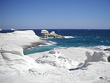
There are about 70 beaches on Milos Island. Hivadolimni Beach is the longest at about 1 kilometre (0.62 mi). The rest of the beaches are starting from (North): Sarakiniko Beach, Papafragas, Kapros, Pachena, Alogomantra, Konstantinos, Mitakas, Mantrakia, Firopotamos, Nerodafni, Lakida, Plathiena, Fourkovouni, Areti, Pollonia, Gourado and Filakopi. (South): Firiplaka, Paliochori, Provatas, Tsigrado, Agia Kyriaki, Psaravolada, Kleftiko, Gerontas, Gerakas, Agios Sostis, Mouchlioti, Katergo, Spathi, Firligos, Pialothiafes, Kalamos, Krotiraki, Psathi, Svoronou and Sakelari. (West): Agios Ioannis, Cave of Sikia, Agathia, Triades and Ammoudaraki. (East): Voudia, Thalassa, Paliorema, Tria Pagidia and Thiafes. (In the Bay Area): Hivadolimni, Lagada, Papikinou, Fatourena, Klima, Skinopi and Patrikia. The North and South and bay beaches are tourist attractions. The east beaches are very quiet, and those to the west are also quiet beaches.
| |||||||||||||


Δεν υπάρχουν σχόλια:
Δημοσίευση σχολίου