antorini (Greek: Σαντορίνη, pronounced [sandoˈrini]), classically Thera (English pronunciation /ˈθɪərə/), and officiallyThira (Greek: Θήρα [ˈθira]), is an island in the southern Aegean Sea, about 200 km (120 mi) southeast of Greece's mainland. It is the largest island of a small, circular archipelago which bears the same name and is the remnant of avolcanic caldera. It forms the southernmost member of the Cyclades group of islands, with an area of approximately 73 km2 (28 sq mi) and a 2011 census population of 15,550. The municipality of Santorini includes the inhabited islands of Santorini and Therasia and the uninhabited islands of Nea Kameni, Palaia Kameni, Aspronisi, and Christiana. The total land area is 90.623 km2 (34.990 sq mi). Santorini is part of the Thira regional unit.[2]
Santorini is essentially what remains after an enormous volcanic eruption that destroyed the earliest settlements on a formerly single island, and created the current geological caldera. A giant central, rectangular lagoon, which measures about 12 by 7 km (7.5 by 4.3 mi), is surrounded by 300 m (980 ft) high, steep cliffs on three sides. The main island slopes downward to the Aegean Sea. On the fourth side, the lagoon is separated from the sea by another much smaller island called Therasia; the lagoon is connected to the sea in two places, in the northwest and southwest. The depth of the caldera, at 400m, makes it impossible for any but the largest ships to anchor anywhere in the protected bay; there is also a fisherman's harbour at Vlychada, on the southwestern coast. The island's principal port is Athinias. The capital,Fira, clings to the top of the cliff looking down on the lagoon. The volcanic rocks present from the prior eruptions featureolivine and have a small presence of hornblende.[3]
It is the most active volcanic centre in the South Aegean Volcanic Arc, though what remains today is chiefly a water-filled caldera. The volcanic arc is approximately 500 km (310 mi) long and 20 to 40 km (12 to 25 mi) wide. The region first became volcanically active around 3–4 million years ago, though volcanism on Thera began around 2 million years ago with the extrusion of dacitic lavas from vents around the Akrotiri.
The island is the site of one of the largest volcanic eruptions in recorded history: the Minoan eruption (sometimes called the Thera eruption), which occurred some 3,600 years ago at the height of the Minoan civilization. The eruption left a large caldera surrounded by volcanic ash deposits hundreds of metres deep and may have led indirectly to the collapse of the Minoan civilization on the island of Crete, 110 km (68 mi) to the south, through a gigantic tsunami. Another popular theory holds that the Thera eruption is the source of the legend of Atlantis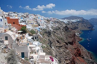
Climate[edit]
Santorini and Anafi are the only locations in Europe to feature a hot desert climate according to the Köppen climate classification system.[25] Santorini generally experiences two seasons. April to October is the warm and dry season and the cold and rainy season lasts from November to March.[26] Total rainfall averages about 38 cm (15 inches) per year. In the summer season, strong winds can also be observed.[27]
Average High/Low Temperature [28]
| Jan | Feb | Mar | Apr | May | Jun | Jul | Aug | Sep | Oct | Nov | Dec | |
|---|---|---|---|---|---|---|---|---|---|---|---|---|
| High °C | 14 | 14 | 16 | 18 | 23 | 27 | 29 | 29 | 26 | 23 | 19 | 15 |
| High °F | 57 | 57 | 60 | 65 | 73 | 81 | 85 | 85 | 79 | 73 | 65 | 59 |
| Low °C | 10 | 10 | 11 | 13 | 17 | 21 | 23 | 23 | 21 | 18 | 14 | 11 |
| Low °F | 50 | 50 | 52 | 56 | 62 | 70 | 74 | 74 | 69 | 64 | 57 | 52 |
Average Rainfall [28]
| Jan | Feb | Mar | Apr | May | Jun | Jul | Aug | Sep | Oct | Nov | Dec | |
|---|---|---|---|---|---|---|---|---|---|---|---|---|
| mm | 71 | 43 | 40 | 16 | 11 | 0 | 7 | 0 | 11 | 38 | 59 | 75 |
| days | 10 | 9 | 7 | 4 | 3 | 0 | 1 | 0 | 2 | 4 | 8 | 11 |
Average Daily Sunshine Hours[28]
| Jan | Feb | Mar | Apr | May | Jun | Jul | Aug | Sep | Oct | Nov | Dec | |
|---|---|---|---|---|---|---|---|---|---|---|---|---|
| Hours | 7 | 7 | 9 | 11 | 12 | 13 | 14 | 13 | 11 | 9 | 8 | 6 |
Average Sea Temperature[28]
| Jan | Feb | Mar | Apr | May | Jun | Jul | Aug | Sep | Oct | Nov | Dec | |
|---|---|---|---|---|---|---|---|---|---|---|---|---|
| °C | 16 | 16 | 16 | 17 | 19 | 22 | 24 | 25 | 24 | 23 | 20 | 18 |
| F | 61 | 61 | 61 | 63 | 66 | 72 | 75 | 77 | 75 | 73 | 68 | 64 |
History[edit]
Minoan Akrotiri[edit]


Excavations starting in 1967 at the site called Akrotiri under the late Professor Spyridon Marinatos have made Thera the best-knownMinoan site outside of Crete, the homeland of the culture. The island was not known as Thera at this time. Only the southern tip of a large town has been uncovered, yet it has revealed complexes of multi-level buildings, streets, and squares with remains of walls standing as high as eight metres, all entombed in the solidified ash of the famous eruption of Thera. The site was not a palace-complex such as are found in Crete, but its excellent masonry and fine wall-paintings show that this was certainly no conglomeration of merchants' warehousing either. A loom-workshop suggests organized textile weaving for export. This Bronze Age civilization thrived between 3000 to 2000 BC, and reached its peak in the period between 2000 and 1580 BC.[29]
Many of the houses in Akrotiri are major structures, some amongst them three storeys high. Its streets, squares, and walls were preserved in the layers of ejecta, sometimes as tall as eight metres, and indicating this was a major town. In many houses stone staircases are still intact, and they contain huge ceramic storage jars (pithoi), mills, and pottery. Noted archaeological remains found in Akrotiri are wall paintings or frescoes, which have kept their original colour well, as they were preserved under many metres of volcanic ash. The town also had a highly developed drainage system and, judging from the fine artwork, its citizens were clearly sophisticated and relatively wealthy people.
Pipes with running water and water closets found at Akrotiri are the oldest such utilities discovered[citation needed]. The pipes run in twin systems, indicating that the Therans used both hot and cold water supplies; the origin of the hot water probably was geothermic, given thevolcano's proximity. The dual pipe system, the advanced architecture, and the apparent layout of the Akrotiri find resemble Plato's description of the legendary lost city of Atlantis, further indicating the Minoans as the culture which primarily inspired the Atlantis legend.[4]
Fragmentary wall-paintings at Akrotiri lack the insistent religious or mythological content familiar in Classical Greek décor. Instead, the Minoan frescoes depict "Saffron-Gatherers", who offer their crocus-stamens to a seated lady, perhaps a goddess. Crocus has been discovered to have many medicinal values including the relief of menstrual pain. This has led many[who?] archaeologists to believe that the fresco of the saffron/crocus gatherers is a coming of age fresco dealing with female pubescence. In another house are two antelopes, painted with a kind of confident, flowing, decorative, calligraphic line, the famous fresco of a fisherman with his double strings of fish strung by their gills, and the flotilla of pleasure boats, accompanied by leaping dolphins, where ladies take their ease in the shade of light canopies, among other frescoes.
The well preserved ruins of the ancient town are often compared to the spectacular ruins at Pompeii in Italy. The canopy covering the ruins collapsed in an accident in September 2005, killing one tourist and injuring seven more. The site was closed for almost seven years while a new canopy was built. The site was re-opened in April 2012.
The oldest signs of human settlement are Late Neolithic (4th millennium BC or earlier), but c. 2000–1650 BC Akrotiri developed into one of the Aegean's major Bronze Age ports, with recovered objects that had come not just from Crete, but also from Anatolia, Cyprus, Syria, and Egypt, as well as from the Dodecanese and the Greek mainland.
Dating of the Bronze Age eruption[edit]

The Minoan eruption provides a fixed point for the chronology of the second millennium BC in the Aegean, because evidence of the eruption occurs throughout the region and the site itself contains material culture from outside. The eruption occurred during the "Late Minoan IA" period at Crete and the "Late Cycladic I" period in the surrounding islands.
Archaeological evidence, based on the established chronology of Bronze Age Mediterranean cultures, dates the eruption to around 1500 BC.[30] These dates, however, conflict with radiocarbon dating which indicates that the eruption occurred at about 1645–1600 BC.[31]Around the time of the radiocarbon-indicated date of the eruption, there is evidence for a significant climatic event in the Northern Hemisphere. The evidence includes failure of crops in China, as well as evidence from tree rings, and an ice core from Greenland. The tree rings date the climatic event to 1628 BC.[32][33]
Ancient and Medieval Santorini[edit]


.jpg)


Santorini remained unoccupied throughout the rest of the Bronze Age, during which time the Greeks took over Crete. At Knossos, in a LMIIIA context (14th century BC), seven Linear B texts while calling upon "all the gods" make sure to grant primacy to an elsewhere-unattested entity called qe-ra-si-ja and, once, qe-ra-si-jo. If the endings -ia[s] and -ios represent an ethnic suffix, then this means "The One From Qeras[os]". If the initial consonant were aspirated, then *Qhera- would have become "Thera-" in later Greek. "Therasia" and its ethnikon "Therasios" are both attested in later Greek; and, since -sos was itself a genitive suffix in the Aegean Sprachbund, *Qeras[os] could also shrink to *Qera. An alternate view takes qe-ra-si-ja and qe-ra-si-jo as proof of androgyny, and applies this name by similar arguments to the legendary seer, Tiresias, but these views are not mutually exclusive. If qe-ra-si-ja was an ethnikon first, then in following him/her/it the Cretans also feared whence it came.[34]
Probably after what is called the Bronze Age collapse, Phoenicians founded a site on Thera. Herodotusreports that they called the island Callista and lived on it for eight generations.[35] In the 9th century BC,Dorians founded the main Hellenic city on Mesa Vouno, 396 m (1,299 ft) above sea level. This group later claimed that they had named the city and the island after their leader, Theras. Today, that city is referred to as Ancient Thera.
In his Argonautica, written in Hellenistic Egypt in the 3rd century BC, Apollonius Rhodius includes an origin and sovereignty myth of Thera being given by Triton in Libya to the Greek Argonaut Euphemus, son of Poseidon, in the form of a clod of dirt. After carrying the dirt next to his heart for several days, Euphemus dreamt that he nursed the dirt with milk from his breast, and that the dirt turned into a beautiful woman with whom he had sex. The woman then told him that she was a daughter of Triton named Kalliste, and that when he threw the dirt into the sea it would grow into an island for his descendants to live on. The poem goes on to claim that the island was named Thera after Euphemus' descendant Theras, son of Autesion, the leader of a group of refugee settlers from Lemnos.
The Dorians have left a number of inscriptions incised in stone, in the vicinity of the temple of Apollo, attesting to pederastic relationsbetween the authors and their lovers (eromenoi). These inscriptions, found by Friedrich Hiller von Gaertringen, have been thought by some archaeologists to be of a ritual, celebratory nature, because of their large size, careful construction and – in some cases – execution by craftsmen other than the authors. According to Herodotus,[36] following a drought of seven years, Thera sent out colonists who founded a number of cities in northern Africa, including Cyrene. In the 5th century BC, Dorian Thera did not join the Delian League with Athens; and during the Peloponnesian War, Thera sided with Dorian Sparta, against Athens. The Athenians took the island during the war, but lost it again after the Battle of Aegospotami. During the Hellenistic period, the island was a major naval base for the Ptolemaic Egypt.
As with other Greek territories, Thera then was ruled by the Romans. When the Roman Empire was divided, the island passed to the eastern side of the Empire which today is known as the Byzantine Empire. According to George Cedrenus, the volcano erupted again in the summer of 727, the tenth year of the reign of Leo III the Isaurian.[37] He writes: "In the same year, in the summer, a vapour like an oven's fire boiled up for days out of the middle of the islands of Thera and Therasia from the depths of the sea, and the whole place burned like fire, little by little thickening and turning to stone, and the air seemed to be a fiery torch."
During the Crusades, the "Franks" – i. e. Catholic Western Europeans – annexed the isle to the Duchy of Naxos and renamed it "Santorini", that is "Saint Irene". Santorini came under Ottoman rule in 1579.
In the Greek State[edit]
Santorini became independent of Ottoman rule in 1821, during the Greek War of Independence, and was united with Greece in 1830 under the Treaty of London.[38]
World War II[edit]
During the Second World War, Santorini was occupied in 1941 by Italian forces and in 1943 by German. In 1944, the German and Italian garrison on Santorini was raided by a group of British Special Boat Service Commandos, killing most of its men. Five locals were shot in reprisal.[39]
Modern Santorini[edit]
Tourism[edit]
In 1956 a major earthquake near Amorgos island resulted in the demolishing of many buildings in the north of Santorini, leading to the desertion of many of its villages. The expansion of tourism has resulted in the growth of the economy and population. The major settlements include Fira (Phira), Oia, Emporio, Kamari, Perissa, Imerovigli, Pyrgos, and Therasia. Akrotiri is a major archaeological site, with ruins from the Minoan era. Santorini's primary industry is tourism, particularly in the summer months. In 2007, the cruise ship MS Sea Diamond ran aground and sank inside the caldera. The island's pumice quarries have been closed since 1986, in order to preserve the caldera. Santorini was ranked the world's top island for many other magazines and travel sites, including the Travel+Leisure Magazine,[40] the BBC,[41] as well as the US News.[42]

Δεν υπάρχουν σχόλια:
Δημοσίευση σχολίου