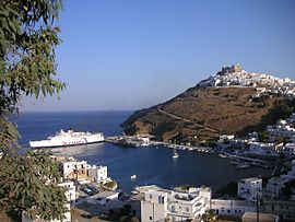
Astypalaia
From Wikipedia, the free encyclopedia
"Stampalia" and "Istanbulya" redirect here. For the Querini Stampalia family, see Querini Stampalia. For the city in Turkey, see Istanbul.
| This article needs additional citations for verification. (July 2013) |
| Astypalaia Αστυπάλαια | |
|---|---|

Astypalaia (harbour)
| |
| Coordinates: 36°33′N 26°21′ECoordinates: 36°33′N 26°21′E | |
| Country | Greece |
| Administrative region | South Aegean |
| Regional unit | Kalymnos |
| Area | |
| • Municipality | 96.85 km2(37.39 sq mi) |
| Highest elevation | 506 m (1,660 ft) |
| Lowest elevation | 0 m (0 ft) |
| Population (2011)[1] | |
| • Municipality | 1,334 |
| • Municipality density | 14/km2 (36/sq mi) |
| Community | |
| Time zone | EET (UTC+2) |
| • Summer (DST) | EEST (UTC+3) |
| Postal code | 859 00 |
| Area code(s) | 22430 |
| Vehicle registration | ΚΧ, ΡΟ, ΡΚ |
| Website | astipalea |
Astypalaia (Greek: Αστυπάλαια, pronounced [astiˈpalea]), known in Italian as Stampalia and in Ottoman Turkish as İstanbulya(استانبوليه), is a Greek island with 1,334 residents (2011 census). It belongs to the Dodecanese, an archipelago of twelve major islands in the southeastern Aegean Sea.
The island is 18 kilometres (11 miles) long, 13 kilometres (8 miles) wide at the most, and covers an area of 97 km2.[2] Along with numerous smaller uninhabited offshore islets (the largest of which are Sýrna and Ofidoussa), it forms the Municipality of Astypalaia, which is part of the Kalymnos regional unit. The capital and the previous main harbour of the island is Astypalaia or Chora, as it is called by the locals
.


Δεν υπάρχουν σχόλια:
Δημοσίευση σχολίου